THX.V $
THX.L
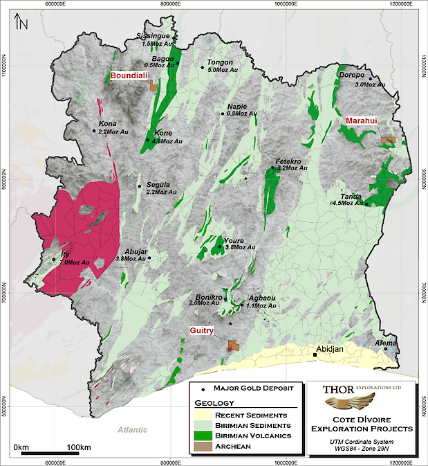
During 2024, Thor expanded its operations into Côte d’Ivoire following the signing of a binding agreement with Endeavour Mining Corporation to acquire a 100% interest in the Guitry Gold Project. Earlier in 2024, the Group entered into an option agreement with Goldridge Resources SARL to acquire an 80% interest in the Boundiali Exploration permit, an early-stage gold exploration project located in northwest Côte d’Ivoire . Later in 2024, the Group entered into an option agreement to acquire up to 80% of the Marahui Exploration permit located in northeast Côte d’Ivoire.
Guitry Project

The Guitry Project is located 220km west of the capital Abidjan comprises two contiguous exploration permits that cover a total of 773km2. The permits encompass rocks belonging to the Tehini Greenstone Belt which extends northwards into Burkina Faso where it hosts large gold deposits such as Houndé (5.2Moz) and Mana (2.3Moz). Early-stage exploration completed by the previous licenceholder,prior to Thor's acquisition, includes 7,672 soil samples and 11,316m of drilling. The Group is currently assessing the legacy database and planning for target-generative geochemical surveys.In Q1 2025, geological mapping combined with reinterpretation of existing data has resulted in the design of an initial 3,000 metre drilling program which commenced Q2 2025.
During May and June 2025, Thor completed an initial 3,000 metre (“m”) reverse circulation (“RC”) drilling program at Guitry and has received initial assay results from the program. The objective of the program was to gain a better understanding of both the geometry and geological controls on gold mineralisation based on a new interpretation of the historic drilling results obtained by Endeavour Mining, the historical owner of the asset.
The assay results received to date from this drilling program include the following highlights:
- Drillhole GURC25-208- 14m at 2.59 grammes per tonne ("g/t") of gold ("Au") from surface
- Drillhole GURC25-209- 4m at 6.87 g/tAu from 38m
- Drillhole GURC25-212- 5m at 7.48 g/tAu from 5m
- Drillhole GURC25-214- 10m at 10.36g/t Au from 57m
- Drillhole GURC25-216- 7m at 3.93 g/tAu from 7m
- Drillhole GURC25-219- 3m at 14.50 g/tAu from 82m
- Drillhole GURC25-221- 13m at 3.46/t Au from 114m
- Drillhole GURC25-227- 7m at 7.71 g/tAu from 77m
- Drillhole GURC25-228- 5m at 12.65 g/tAu from 69m
- Drillhole GURC25-229- 17m at 2.16 g/tAu from surface
Further exploration at the Krakouadiokro Prospect will include both infill and step-out drilling. Additionally, drilling will commence on numerous geochemical anomalies at both the Krakouadiokro and Gbaloukro Prospects, many of which remain untested or only partially tested.
Marahui Permit
The Marahui permit is a 250 sq. km permit located in the Bondoukou region, northeastern part of Côte d’Ivoire at around 450 km of Abidjan, economic capital of Côte d’Ivoire.The Marahui permit is composed of volcano-sedimentary rocks which are intruded by granitoids (granite). In the contact zone, volcano-sediments show strong foliation and silicification. Observed gold mineralization is controlled by a NW-SE shear zone in volcano-sediment and by extensional WNW-ESE quartz veins in granite. Exploration activities commenced in Q4 2025 consisting of detailed mapping and a comprehensive soil geochemical sampling program undertaken to define drill targets in a previously unexplored portion of Birimian Greenstone. The soil geochemistry sampling defined two parallel anomalous structures, with the larger one being a 4km long by 200m wide anomaly. Follow up rock chip sampling from artisanal activity on the defined structure confirmed bedrock mineralisation with results including 19.3g/t Au, 10g/t Au and 9.97g/t Au. In Q1 2025, soil geochemistry sampling and geological mapping continued and defined two parallel anomalous structures, with the larger one being a 4km long by 200m wide anomaly. Follow up rock chip sampling from artisanal activity on the defined structure confirmed bedrock mineralisation with results including 19.3g/t Au, 10g/t Au and 9.97g/t Au.,Further exploration activity has continued in 2025 with drilling activities commencing in Q3 2025